Nicholas Kosar
Wells + Associates collaborated closely with the General Services Administration (GSA) to develop a geospatial tool. Our team created the Geospatial Mobility Assessment Process (G-MAP), a comprehensive tool designed to address the complex challenges of connectivity and commuting for federal facilities.
By aligning with regional planning initiatives such as the Metropolitan Washington Council of Governments’ (MWCOG) “Visualize 2045” and the Comprehensive Plan goals of the National Capital Planning Commission, our G-MAP tool endeavors to bring government jobs and housing closer together while prioritizing efficient and eco-friendly travel options.
What is the Geospatial Mobility Assessment Process?
G-MAP is a tool developed to help the General Services Administration (GSA) pick the best locations for federal buildings in the National Capital Region (NCR).
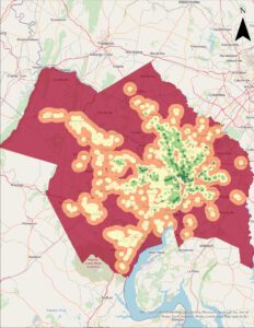
What does G-MAP do?
- Evaluates different scenarios based on factors like where people live and how they get to work.
- Improves access to different transportation options like buses, trains, and bikes.
- Helps match federal job locations with where people live to make commuting easier.
Why is G-MAP useful?
- Helps GSA pick better locations for federal buildings.
- Makes it easier for employees to get to work without relying on cars.
- Supports regional and federal planning goals.
Adapting Commuting Patterns in the Era of Telework
During the COVID-19 pandemic, commuting patterns in the National Capital Region (NCR) underwent significant changes due to a rise in telecommuting, offering temporary relief from congestion. As federal agencies grapple with the complexities of site selection in the NCR, G-MAP emerges as a transformative solution. It equips GSA staff with data-driven insights and strategic direction, prioritizing transportation connectivity, sustainability, and stakeholder collaboration. G-MAP embodies GSA’s commitment to fostering efficient, resilient, forward-looking federal facilities in the NCR.


